See exactly where your project stands against the plan.
Aarivix turns each site capture — by drone or 360 camera — into a measured reality model, aligned to your design and tracked across every milestone. One objective source of truth for developers and project managers.
Capture, align, flag. Three steps from site to source of truth.
No more guesswork between site visits. Aarivix turns every capture into a measured, versioned record of exactly how your site stands.
Capture the site, any way you can reach it
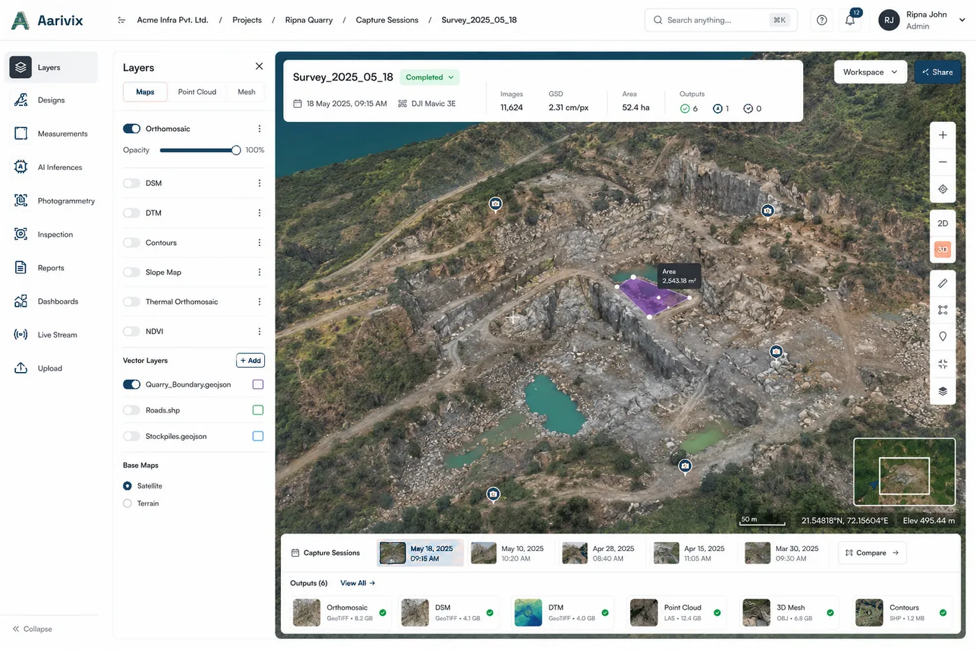
Fly it by drone or walk it with a 360 camera. Aarivix turns the capture into a measured orthomosaic, terrain model and point cloud — registered to your control points — for open ground, interiors and vertical structures alike.
Align reality to the design
Aarivix locks each capture to your as-designed plan and to earlier captures — one shared coordinate frame — so every bench, surface and structure is compared like-for-like.
Measure what changed, flag what’s off
Volumes, levels and deviations are computed automatically. Every change from the plan is flagged with a signed figure and a clear audit trail — ready to drop into a progress or payment report.
Questions, measured answers.
Everything developers and project managers ask before their first capture.
Aarivix produces a survey-grade reality model, registered to your established ground control points. Every deviation from the plan is reported as a signed figure with its tolerance band — so you, your PMC and your contractor see not just that something moved, but how far and in which direction. One independent record everyone works from.
A survey-grade drone or a 360 camera — whatever suits the site. Aarivix is hardware-agnostic: it ingests the imagery, registers it to your control points, and builds the reality model regardless of how the site was captured. Drone for open ground, 360 camera for interiors and vertical structures.
Import IFC, DWG and design surfaces (DTM / TIN). Aarivix locks the as-built capture to your as-designed intent in a single shared coordinate frame, then versions every comparison against your project milestones.
Roughly four hours from capture to an aligned reality model for a typical site. From there a progress or payment report — flagged deviations, cut/fill volumes and level checks with a full audit trail — is one click away.
Reality models, imagery and designs are encrypted in transit and at rest, with role-based access per project. Aarivix is the objective record of your site, and that record stays yours.
Stop guessing between site visits. Measure the site.
Bring one objective source of truth to your next milestone — the record you, your PMC and your contractor all work from.